My diary comments that "the biggest giggle was skiing roped together across suspicious terrain for nearly three hours and I fell several times". Badly adjusted ski bindings were the problem. The crevassed ground turned out to be shattered shelf ice. We found an ice knoll and were able to survey the surrounding area. The ground ahead was much broken and looking back there was a dip. On the horizon we could see the hut.
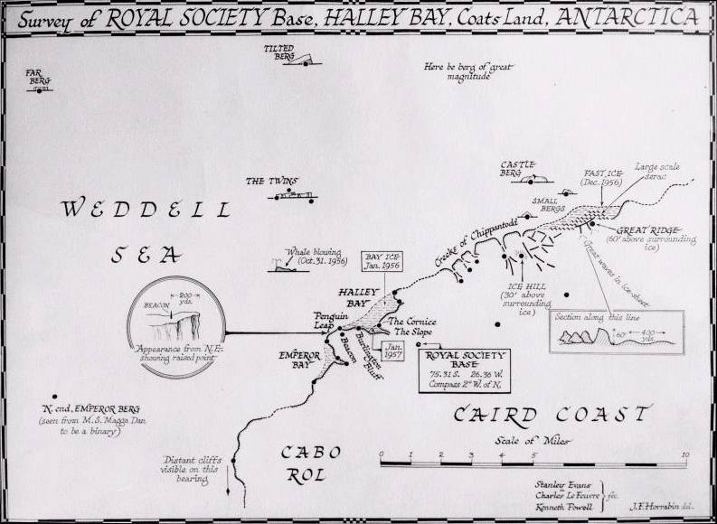
Stan, Charlie, and Ken Powell later produced a survey map that was redrawn by J.F. Horrabin when we were back in the UK.

Survey of the Royal Society base, by Evans, Le Feuvre and Powell.
From the BAS Archives. Document reference: AD6/2Z/1961/A1
"Gin Bottle" - Although my memory is hazy on this point, I think we probably celebrated our excursion by leaving a gin bottle on the ice knoll because by 1957 Joe MacDowall's book on On Floating Ice, page 162, describes a trip that Robin Smart, Bill Bellchambers and David Harrison made to the McDonald Ice Rumples on 14th October 1957.
The most marked feature of the disturbed area was the ice hill formed by the floating ice shelf lifted up over a subsurface hill and known as the "Gin Bottle" which was about 6 miles (9.7 km) from base.
Some later quotes from On Floating Ice for 1958 are
p.219:-
October 15 - Philip (Brennan) and Les (Barclay) proposed a visit to the Gin Bottle area on Thursday, to return about 4 p.m.
October 16 - Les and Philip skied to the Gin Bottle area. They tried to find a way down to the sea ice but were not successful either there or at the Chippantodd CreeksLater on p 232:-
Les gave me the position of the three flags used to mark the geomagnetic survey . He said that the 30 ft (9 m) ice-hill near the Gin Bottle was in the same position as marked by a stake last year. The headland had gone which lay to the north of this hill and between the two peaks of Chippantodd.
The results of a plain table survey by Les Barclay in November and December 1958 will be found in Volume IV of The Royal Society IGYE, Halley Bay, 1956-1959, Sledging and Surveying, pp. 329 - 338.
[10th September 2007]